|
 |
|
Our route
-I:
07.01.05 - 09.01.05:
Puerto Natales
10.01.05 - 21.01.05:
NP Torres del Paine
Our route - II:
04.02.05 -
06.02.05:
Chile Chico
Bahia Jara
07.02.05 - 08.02.05:
NP Cerro Castillo
09.02.05 - 10.02.05:
Carretera Austral
Coyhayque
NP Rio Simpson
11.02.05 - 12.02.05:
Carretera Austral
NP Quelat
13.02.05:
Futaleufu
Our route
- III:
14.03.05 - 16.03.05:
Aguas Calientes
17.03.05 - 20.03.05:
El Caulle
NP Puyehue
21.03.05 - 22.03.05:
Entre Lagos
Aguas Calientes
23.03.05:
Frutillar
Puerto Varas
24.03.05 - 27.03.05:
Petrohue
Volcan Osorno
Ralun
28.03.05 - 29.03.05:
Valdivia
Fuerta Niebla
30.03.05 - 01.04.05:
Pucon
Volcan Villarica
02.04.05 - 04.04.05:
Vn.Lonquimay
05.04.05 - 06.04.05:
Chillan
07.04.05 - 08.04.05:
Cobquecura
Buchupureo
Constitution
09.04.05 - 10.04.05:
Valle de Maule
San Javier
Yerbas Buenas
Talca
11.04.05 - 12.04.05:
Santiago de Chile
Valparaiso
NP La Campana
Our
route - IV:
09.06.05 - 14.06.05:
Jujuy (ARG)
15.06.05 - 16.06.05:
Paso de Jama
17.06.05 - 20.06.05:
San Pedro de A.
21.06.05 - 22.06.05:
Calama
Chuquicamata
23.06.05 -24.06.05:
San Pedro de A.
Calama
25.06.05 - 26.06.05:
Humberstone
Santa Laura
27.06.05 - 02.07.05:
Arica
03.07.05 - 04.07.05:
Putre
Termas Jurasi
05.07.05 - 06.07.05:
NP Lauca
Our route
- V:
20.12.05 - 21.12.05:
Arica
22.12.05:
Cobija
23.12.05:
Antofagasta
Juan Lopez
24.12.05:
Bolsico
25.12.05:
Chanaral
26.12.05:
La Serena
27.12.05:
Curico
28.12.05 - 30.12.05:
Lonquimay
Our route
- VI:
11.02.06 - 14.02.06:
NP Puyehue
Pampa Frutilla
Aguas Calientes
|
| |
|
| Chile |
|
|
|
|
|
|
On this page, we (will) describe our experiences in
Chile. Apart from the travelogue for this country you will also find
a number of links to useful sites, ranging from general information
to embassy homepages.
Content:
Part
1: Torres del Paine (07.01.05 - 21.01.05)
Part
2: The Carretera Austral (04.02.05 - 13.02.05)
Part 3: The Lake District (14.03.05 -
13.04.05)
Part 4: Norte Grande (15.06.05 -
06.07.05)
Part 5: Christmas 2005 (12.12.05 -
30.12.05)
Part 6: Los Lagos II (11.02.06 -
14.02.06)
Part 1: Torres del Paine (07.01.05 -
21.01.05)
Written by:
Dorrit
 And again we
cross the Magellan Strait with the little ferry, but this time we
stay in Chile. We pass through the steppe to the cute harbour town
of Puerto Natales, splendidly located at a deep fjord and consisting
of wooden houses in all kinds of bright colours. It seems to live on
its nearness to the famous national park Torres del Paine and it is
here that we prepare ourselves a few days for the ten day trek we
want to do in the park (the so called Torres del Paine Circuit, that
rounds the range) and get a permit for the dogs. We leave the town
via its bay, where black necked swans swim between brightly coloured
wooden fishing boats and drive the 150 km (Puerto Natales is
considered "near" the park by Chilean standards, since there simply
is nothing that is nearer..) over an unpaved road through the low,
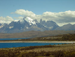
brown Patagonian hills to Torres del Paine national park. Suddenly
the range looms ahead of us; with its up to 3000 m high peaks it is
on average some 2000 m higher than the surrounding hills and sticks
out as a rocky island from the sea. The range has been pushed up by
a subterranean lava stream a long, long time ago and stuck out high
above its surroundings. Glaciers, weather and wind have cut deep
crevices into the range, turning it from a normal range into a
cluster of the most curiously shaped peaks and valleys. And again we
cross the Magellan Strait with the little ferry, but this time we
stay in Chile. We pass through the steppe to the cute harbour town
of Puerto Natales, splendidly located at a deep fjord and consisting
of wooden houses in all kinds of bright colours. It seems to live on
its nearness to the famous national park Torres del Paine and it is
here that we prepare ourselves a few days for the ten day trek we
want to do in the park (the so called Torres del Paine Circuit, that
rounds the range) and get a permit for the dogs. We leave the town
via its bay, where black necked swans swim between brightly coloured
wooden fishing boats and drive the 150 km (Puerto Natales is
considered "near" the park by Chilean standards, since there simply
is nothing that is nearer..) over an unpaved road through the low,
brown Patagonian hills to Torres del Paine national park. Suddenly
the range looms ahead of us; with its up to 3000 m high peaks it is
on average some 2000 m higher than the surrounding hills and sticks
out as a rocky island from the sea. The range has been pushed up by
a subterranean lava stream a long, long time ago and stuck out high
above its surroundings. Glaciers, weather and wind have cut deep
crevices into the range, turning it from a normal range into a
cluster of the most curiously shaped peaks and valleys.
 We park the
car, grab our backpacks and start the ten-day tour around the range.
It starts with a hike through a valley to a lookout point over the
three "Torres del Paine" that give the park its name. These three
pillars stick out far above the valley like a kind of upright
standing baguettes and are so steep and smooth that snow cannot find
any hold on their slopes and lies in heaps at their feet. The
pillars form the 2500m high, vertical western shore of a green
mountain lake that is bordered by a high moraine wall on its other
side. It is along this moraine wall that we have to climb to the
viewpoint; a steep climb up and a "knee popping descent" down
afterwards. We park the
car, grab our backpacks and start the ten-day tour around the range.
It starts with a hike through a valley to a lookout point over the
three "Torres del Paine" that give the park its name. These three
pillars stick out far above the valley like a kind of upright
standing baguettes and are so steep and smooth that snow cannot find
any hold on their slopes and lies in heaps at their feet. The
pillars form the 2500m high, vertical western shore of a green
mountain lake that is bordered by a high moraine wall on its other
side. It is along this moraine wall that we have to climb to the
viewpoint; a steep climb up and a "knee popping descent" down
afterwards.
The next leg of the journey takes us through
heath fields passing deep blue ponds and the great mint-coloured
glacial lake Lago Nordenskjold. According to our travel guide, the
strange colour of glacial lakes is caused as follows: "Snow coming
from the Pacific falls onto the glacier and as the weight increases,
compacts to ice. This extra weight forces the glacier to move. As it
pushes along, the melted ice on the bottom mixes with rock and soil,
grinding it up by its movement. When the glacier melts into lakes,
it dumps also the ground-up rock, giving the water a milky, grey
colour. This same sediment remains unsettled in some lakes and
diffracts the sunlight, creating stunning turquoise, pale-mint or
azure colours."
The contrast with the dark blue non-glacial
lakes, that we can see lying next to Lago Nordenskjold from the high
mountain slope we are walking along, is indeed stunning. It is quite
stormy that day (the area south of the 40th latitude on this
continent is known for its storms called 'roaring forties' and
'furious fifties' (and as we are at 51° here, the storms are furious
indeed) and for its unpredictable weather) and on the high mountain
slope we find only little cover from the wind. Before we set off, I
had been smiling scornfully as I read in the trekking guide that
people sometimes get blown off the path, but when I suddenly found
myself sprawling in the scrubs below the trail my scorn was soon
forgotten. After that I was a lot more careful, after all, the
mountain slope is quite steep and not all the trail is lined by
scrub to catch you when you fall.
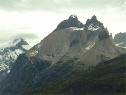
The hike ends at the foot of
three mountains called "Cuernos" (horns) for their strange forms and
colours: the entire mountain is beige, but the top is black, making
the mountain looking like a kind of cake with chocolate dip. Hmm,
after three days of instant noodles I start to see food in the
mountain forms... and we still have 7 days more to go!
 We make a
little excursion to the Valle de Frances, one of the best hikes
during this trek. The Valle de Frances is a narrow valley between
glacier-covered, 3000 m high mountains to the west and the curiously
shaped Cuernos and Torres del Paine to the east. Behind us (i.e.
south of us) the valley slopes down and permits a great view over
the snow-capped mountains of the Southern Cordillera and in front of
that the green and blue lakes. The valley ends to the north in a
kind of huge amphitheatre; a grand mossy plain surrounded by a ring
of towering mountains, one more curiously shaped than the other.
Simply awesome. The hanging glaciers on the mountains (especially
Cerro Paine) break off regularly and fall down with a loud crash
into the rushing river below, which transports the chunks of ice on
to one of the many lakes. We make a
little excursion to the Valle de Frances, one of the best hikes
during this trek. The Valle de Frances is a narrow valley between
glacier-covered, 3000 m high mountains to the west and the curiously
shaped Cuernos and Torres del Paine to the east. Behind us (i.e.
south of us) the valley slopes down and permits a great view over
the snow-capped mountains of the Southern Cordillera and in front of
that the green and blue lakes. The valley ends to the north in a
kind of huge amphitheatre; a grand mossy plain surrounded by a ring
of towering mountains, one more curiously shaped than the other.
Simply awesome. The hanging glaciers on the mountains (especially
Cerro Paine) break off regularly and fall down with a loud crash
into the rushing river below, which transports the chunks of ice on
to one of the many lakes.
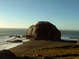
The route continues westward,
around the Paine-range and from there to the north along the huge
glacial lake Lago Grey, which is fed by the 17 km long glacier Grey.
This in turn is only a finger of the 320 km long, 14,000 km² large
ice field Hielo Sur, the largest ice cap outside the polar regions.
From the trail we have many great views over the glacier and the ice
field behind it; a gigantic, blindingly white plain as far as you
can see. Every now and then a small dark-grey peak, partly covered
in snow, sticks out above the ice, making it look even more
desolate. This is how large parts of the world must have looked like
during the ice ages. There is a campground near the "snout" of the
glacier, at the lake shore. From our tent we can see small, light
blue icebergs floating by in the grey-green water. After breaking
off the glacier, these chunks of ice slowly melt away in the lake.
From here the trail continues along the steep mountain slope,
high above the glacier and the ice cap, so that all you see when you
look west is ice. We feel very small and insignificant. The storm
has increased in strength, making it impossible to walk upright
along the steep and coverless slope.
 Since it has
started to rain we are not sure if we should cross the 1400 m pass;
we are walking the route in opposite direction and the climb up is
supposed to be extremely steep and slippery, especially after rain.
We decide to go anyway and struggle up the 800 m over indeed very
steep and slippery mud until the upper tree line. From there, there
is no more cover against the rain, which turns into snow and later
hail the further up we go. What made us think it is midsummer here
anyway? Since it has
started to rain we are not sure if we should cross the 1400 m pass;
we are walking the route in opposite direction and the climb up is
supposed to be extremely steep and slippery, especially after rain.
We decide to go anyway and struggle up the 800 m over indeed very
steep and slippery mud until the upper tree line. From there, there
is no more cover against the rain, which turns into snow and later
hail the further up we go. What made us think it is midsummer here
anyway?
The dogs are shivering and squeaking for cold so we
hurry to get down from the pass, through a moonscape of rock,
stones, gravel and snow. After one more cold hour we cross the tree
line on the other side again and are at least a little protected
against the storm. What follows is a horrible stretch through a
black mud-swamp, in which we sink knee-deep several times and I
nearly lose a shoe. At last we reach the campground, but the plank
over the river in front of it is not stable and Coen - holding
Manali under his arm - falls half into the river, soaking both
himself, the dog and the tent. When we set up the tent in the rain,
we find out that the sleeping bags are also wet and thus a
sleepless, cold and wet night of waiting for dawn follows. At 5:30
am it is finally light enough to leave and we quickly start walking
to warm up again. We are lucky; the weather has improved and we are
able to dry our things in the afternoon. The last two days are easy
walks compared to the rest, through beautiful fields full of flowers
along the river bank, where wild goose nest and gaucho's in
traditional clothes pass you by on ox-carts. During one of our
breaks Shimal gets into a fight with a skunk. The animal defends
itself in its own fashion and sprays green stuff around, leaving
Shimal with a mouth that foams better than the best dishwashing
liquid. We rinse it as best as we can, but the smell is terrible and
stays for days. And it is too cold to let him sleep outside, so we
will have to share the tent with him that night! The last 20 km we
cross a steppe, having a great view of the Torres del Paine, a view
we cannot get enough of. Still, we are happy to be back at the car;
after a 10-day 1000 calory-diet of instant noodles and biscuits at 6
hours of climbing and descending per day all that is still big about
us are our knees and feet. We are more than ready for some real food
and a soft bed. We are happy to find that our Swiss friends Adi and
Tanja are in Torres del Paine too and spend a couple of days
sitting, eating, drinking and chatting with them before returning to
Argentina.
Dorrit
Click here to read about our experiences in Argentina
first before continuing with the next part of our Chile
travelogue.
Part 2: The Carretera Austral
(04.02.05 - 13.02.05)
Written by:
Dorrit
 At the border we give Rodrigo, a student from Santiago, a lift to
Chile Chico. In this little village we book the ferry over the lake
to Puerto Ingeniero Ibanez at the northern shore, thus saving 270 km
of bad unpaved road. We have to wait 3 days for the ferry and do
this at a splendid little beach with nice green trees at the border
of the international lake Lago Buenos Aires (Argentina) / Lago
General Carrerra (Chile). The water in this huge lake is deep blue
and if you stand at its shores it looks so clear that you can see
every little stone at the bottom. It seems as if it is filled with
drinking water. Rodrigo visits us and tells us there is a
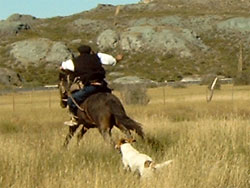
folklore-festival in the neighbouring village Bahia Jara. Together,
we drive there and end up at a meadow near an estancia (large cattle
farm), where a podium is built on top of large haystacks and food
and drinks are sold from little stands. Men in traditional wear play
a game where one throws a piece of bone and the rest gambles on
which side it will fall down on. Further down, people can
participate in a horse contest; one of the wild horses should be
caught, saddled with a sheep skin and ridden to the far side of the
meadow. Most of them manage to catch and saddle the horse, but none
of them makes it to the far side of the meadow, all are flying off
the horse after a couple of metres and land in the grass. At 8 pm
live music and dance starts. An accordion and a guitar player play
folk music, to which a dance group in traditional outfit is dancing
some folk dance. The men are wearing costumes which remind me of
18th century Spain; black and tight fitting suits with a bright red
waistband and a hat with broad rim, the women wide white blouses and
colourful skirts. Many visitors to the festival appear to know the
dance and before long most are dancing between or with the dance
group.
At the border we give Rodrigo, a student from Santiago, a lift to
Chile Chico. In this little village we book the ferry over the lake
to Puerto Ingeniero Ibanez at the northern shore, thus saving 270 km
of bad unpaved road. We have to wait 3 days for the ferry and do
this at a splendid little beach with nice green trees at the border
of the international lake Lago Buenos Aires (Argentina) / Lago
General Carrerra (Chile). The water in this huge lake is deep blue
and if you stand at its shores it looks so clear that you can see
every little stone at the bottom. It seems as if it is filled with
drinking water. Rodrigo visits us and tells us there is a
folklore-festival in the neighbouring village Bahia Jara. Together,
we drive there and end up at a meadow near an estancia (large cattle
farm), where a podium is built on top of large haystacks and food
and drinks are sold from little stands. Men in traditional wear play
a game where one throws a piece of bone and the rest gambles on
which side it will fall down on. Further down, people can
participate in a horse contest; one of the wild horses should be
caught, saddled with a sheep skin and ridden to the far side of the
meadow. Most of them manage to catch and saddle the horse, but none
of them makes it to the far side of the meadow, all are flying off
the horse after a couple of metres and land in the grass. At 8 pm
live music and dance starts. An accordion and a guitar player play
folk music, to which a dance group in traditional outfit is dancing
some folk dance. The men are wearing costumes which remind me of
18th century Spain; black and tight fitting suits with a bright red
waistband and a hat with broad rim, the women wide white blouses and
colourful skirts. Many visitors to the festival appear to know the
dance and before long most are dancing between or with the dance
group.
 We cross the
lake in 2 hours and from the northern shore start our journey over
the Carretera Austral, the road from Puerto Montt to the "south" of
Chile (at the moment it is not going much further than Chile Chico).
It is indeed a lot greener and moister than on the other side of the
Andes and we are enjoying a great drive through a Swiss looking
landscape to Coyhayque. Our plan to walk in the national park Cerro
Castillo has to be given up, since dogs are (again) not allowed;
this park is (like Fitz Roy) dedicated to save a nearly extinct
South-American deer. Instead we settle down on a nice forested
campground and do nothing for two days. We read, prepare the trip
for the coming time and try to keep the many horse-flies away from
us. We do some shopping in Coyhayque and move on to National Park
Rio Simpson, through a great alpine landscape of green grassy hills
full of purple, white and yellow flowers. We pass cute wooden houses
painted pastel and white and little farms where geese and chicken
walk in the yard and men wearing big black hats drive small herds of
cows along the road or are riding ox-charts full of hay towards
small wooden barns. Gold-coloured fields of corn lie in front of
snow-capped mountains covered in dark green pine forests. A happy
little river in the foreground and ready is your Bob Ross picture!
Everywhere along this happy little river we find great spots to
spend the night and thus the days fly by while we swim in the river
(it is very hot here and the crystal-clear water is very inviting)
and celebrate a well deserved holiday. We cross the
lake in 2 hours and from the northern shore start our journey over
the Carretera Austral, the road from Puerto Montt to the "south" of
Chile (at the moment it is not going much further than Chile Chico).
It is indeed a lot greener and moister than on the other side of the
Andes and we are enjoying a great drive through a Swiss looking
landscape to Coyhayque. Our plan to walk in the national park Cerro
Castillo has to be given up, since dogs are (again) not allowed;
this park is (like Fitz Roy) dedicated to save a nearly extinct
South-American deer. Instead we settle down on a nice forested
campground and do nothing for two days. We read, prepare the trip
for the coming time and try to keep the many horse-flies away from
us. We do some shopping in Coyhayque and move on to National Park
Rio Simpson, through a great alpine landscape of green grassy hills
full of purple, white and yellow flowers. We pass cute wooden houses
painted pastel and white and little farms where geese and chicken
walk in the yard and men wearing big black hats drive small herds of
cows along the road or are riding ox-charts full of hay towards
small wooden barns. Gold-coloured fields of corn lie in front of
snow-capped mountains covered in dark green pine forests. A happy
little river in the foreground and ready is your Bob Ross picture!
Everywhere along this happy little river we find great spots to
spend the night and thus the days fly by while we swim in the river
(it is very hot here and the crystal-clear water is very inviting)
and celebrate a well deserved holiday.
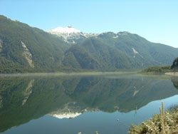
 Further
north the landscape becomes rougher and we pass perfectly still
lakes that mirror their green shores and the mountains further away
to perfection; we make picture after picture. The road becomes
narrower and bumpier and some parts are nothing more than a gravel
trail through a thick jungle of huge trees, bamboo, ferns and a road
plant with leaves that are like huge hands, measuring 2 m². We have
to wait half a day for road construction: the road is blocked until
6 pm. When we are finally allowed to move on the stretch proves
hardly passable, deep mud holes (in which a truck gets stuck in
front of us), sharp stones that stick out of the road and heaps of
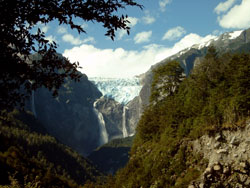
construction rubbish make it hard to drive here. In National Park
Quelat the jungle gets even thicker and we seem to drive between to
solid green walls. We pass a beautiful, deep-blue fjord and visit
Glaciar Colgante, an impressive hanging glacier. Over a saddle
between two mountains the light blue ice comes forward, high above
the green-green lake in which it empties itself in the form of two
large waterfalls of some hundred metres high. Further
north the landscape becomes rougher and we pass perfectly still
lakes that mirror their green shores and the mountains further away
to perfection; we make picture after picture. The road becomes
narrower and bumpier and some parts are nothing more than a gravel
trail through a thick jungle of huge trees, bamboo, ferns and a road
plant with leaves that are like huge hands, measuring 2 m². We have
to wait half a day for road construction: the road is blocked until
6 pm. When we are finally allowed to move on the stretch proves
hardly passable, deep mud holes (in which a truck gets stuck in
front of us), sharp stones that stick out of the road and heaps of
construction rubbish make it hard to drive here. In National Park
Quelat the jungle gets even thicker and we seem to drive between to
solid green walls. We pass a beautiful, deep-blue fjord and visit
Glaciar Colgante, an impressive hanging glacier. Over a saddle
between two mountains the light blue ice comes forward, high above
the green-green lake in which it empties itself in the form of two
large waterfalls of some hundred metres high.
Through the
fabulous Futaleufu valley we go back to Argentina, where we want to
do some trekkings in the Lake District.
Dorrit
Click here to read about our experiences in Argentina
first before continuing with the next part of our Chile
travelogue.
Part 3: The Lake District (14.03.05 -
13.04.05)
Written by: Coen
Via a
road over a pass, that climbs through a barren rocky landscape, we
enter Chile. It rains and it is cold. Fortunately our next
destination is Aguas Calientes. As the name suggests: hot water.
This relaxing 40° C hot bath, situated at the riverside, is nicer
than ever when it rains.
 Around
the thermal park are some walking trails and after we have walked a
few treks in the deep green forest full of mosses and alerces, we
find a nice spot to camp at the riverside. Here we start preparing
our next trek: in 5 days around Volcan Puyehue. Around
the thermal park are some walking trails and after we have walked a
few treks in the deep green forest full of mosses and alerces, we
find a nice spot to camp at the riverside. Here we start preparing
our next trek: in 5 days around Volcan Puyehue.
We lift our
backpacks on our backs and start with a 1000 meter climb in 7 km, in
the rain. The trail climbs steadily through a forest with volcanic
grit. The rain has worn out deep trenches. The higher we get, the
blacker the volcanic grit gets. We pant in our rain suits that
doesn't allow any oxygen in or out. Finally we arrive at the
refugio, a wooden hut. Here we find a confused Swiss guy who was
lost the day before and spent the whole night walking around in the
cold outside. We managed to light some fire in the stove and
together with two Germans and two Israeli we spent a nice camping
night.
In the morning we start a wonderful tour through a
Sahara-like volcanic landscape because everything is above tree line
and completely barren since a volcanic outbreak some years ago. The
weather is clear and we have magnificent views over the surrounding
volcanoes: Osorno, Tronador and Lanin. We a pass a kilometres long
black stream of dried up lava and at the horizon we see several
meters high fumaroles (smoking geysers) erupting from the earth.
Through the barren and sulphite colored mountains, specked with
blocks of yellow, red and green sulphite crystals, we walk uphill
and downhill. We pitch our tent at a riverside, which banks are
completely yellow, orange and grey because of all the volcanic
minerals and everywhere hot water boils up. In front of our tent
somebody has conveniently dug a pool filled with hot thermal water,
so we jump in and spend the afternoon in the hot tub. The sun is
shining and the panorama fantastic.
Unfortunately, it starts
raining in the evening.
Quotation from my diary:
"...in the evening it started raining. It rained very
hard, the whole night through. Then finally daylight appeared. But
it started to rain even harder and wind started blowing. We could
only leave our tent in a rain suite. The rain and the wind
penetrated everything. We could not even make ourselves a cup of
tea. So we sat the whole day in our tent. It wasn't even dry for a
minute. We hoped the rain would stop in the afternoon so we could
visit some geysers but unfortunately it didn't stop raining, the
wind became a storm and it was getting dark again. We had a very
uncomfortable night before us. It rained and stormed non-stop and
during the night we were surprised by lightning and thunder. Rain
was pouring so hard that our tent was standing in a pool of water,
not a very nice thought considering we were the highest point in the
area in the midst of a thunderstorm. It was a very miserable night.
I was afraid our outside tent would fly away and I saw ourselves
sitting alone, outside in the dark, in the rain, in the middle of
nowhere with two dogs. Fortunately dawn broke after 36 ours of
non-stop rain. For breakfast we had a few muesli bars, swallowed
away with sulphur water (the river with clean drinking water had
risen so high that it had mixed with the thermal water). We quickly
packed our stuff together. Everything was wet and cold. It was still
raining and storming. We walked quickly uphill, downhill, uphill,
downhill. Then suddenly fog broke in so we had much difficulties in
finding the trail. The only orientation we had were some bamboo
stakes, which we couldn't see because of the fog. A few times the
dogs found the trail and a few times Dorrit stayed at the last stake
and I went searching for the next one in different directions.
During the last part, it started hailing….hard to describe how happy
we were to arrive at the refugio. Completely soaked and cold to the
bones we made a tea but first we had to filter the water through a
sock because due to the heavy rainfall, the stream of drinking water
here had also swollen into a muddy flood…."
Of course we
did not feel like spending another night in the rain so we took some
Dextro Energy and walked another day's march to the car this same
day.
We drove to a campsite in Entre Lagos, where, with a
chocorum and the heater on, we enjoy being in our car again.
After another visit to the thermal baths in Aguas Calientes
to treat our stiff walking legs, we drive to Frutillar. This
picturesque village is situated at a lake with volcano Osorno at its
horizon. Then we drove to Puerto Varaz. Both these villages are in
an area with many inhabitants from German origin and therefore there
are a lot of German-colonial houses, blond people and a lot of
"Kuchen" (great German pastries).
 In Chile
it is usually difficult to find a suitable place to spend the night
because every m2 is fenced. We are often able to find a good, quiet
spot though, even if it sometimes takes more than an hour searching.
Autumn is coming and we can often collect a delicious blackberry
dessert. In Chile
it is usually difficult to find a suitable place to spend the night
because every m2 is fenced. We are often able to find a good, quiet
spot though, even if it sometimes takes more than an hour searching.
Autumn is coming and we can often collect a delicious blackberry
dessert.
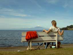
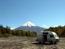 Volcano Osorno keeps us in her spell for another while:
via a tour through rough volcanic landscape, with a wild river full
of huge lava rocks, we drive to Petrohue, the far end of a volcanic
peninsula. After crossing a valley, recently flooded with mud, we
arrive at a black lava sand beach on the shore of a perfect blue
lake, surrounded by green hills. With a view on the volcano Osorno
we camp here for two days. A perfect spot. Volcano Osorno keeps us in her spell for another while:
via a tour through rough volcanic landscape, with a wild river full
of huge lava rocks, we drive to Petrohue, the far end of a volcanic
peninsula. After crossing a valley, recently flooded with mud, we
arrive at a black lava sand beach on the shore of a perfect blue
lake, surrounded by green hills. With a view on the volcano Osorno
we camp here for two days. A perfect spot.
Then it is time
to drive on to the north, which we want to do via the coast. First
we visit fort Niebla, part of a fortification at a strategic estuary
of three rivers. We camp in front of the fort and for the first time
we see the Pacific Ocean. We wait to see a perfect sunset at the
broad bay.
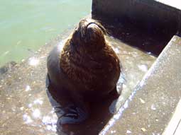 Before we move on, we visit Valdivia, a small coastal
town, where we walk around on the local fish market. Like stray cats
the enormous sea lions and cormorants beg for the fish leftovers. Before we move on, we visit Valdivia, a small coastal
town, where we walk around on the local fish market. Like stray cats
the enormous sea lions and cormorants beg for the fish leftovers.
For the first time we take the asphalted, well maintained, 4
lane (and expensive) Panamericana-highway. Nobody here has the money
to drive the Panamericana so except for some plastic-flower sellers
we drive alone to Pucon, through the bright yellow autumn forest.
Pucon is a touristy town from where you can climb to the
crater of Volcan Villarica. It is the most active volcano in the
area. Because the magma level in the crater is very high, you can
see it bubble when you are standing on the crater rim.
We
explore the area around Pucon and we visit fantastic thermal baths
on a riverside with 5 baths surrounded by huge rocks. Near Pucon, we
found a camping spot in the forest, to which we returned every
night. The logging workers, whose oxen where tied together with a
wooden beam, didn't bother us being here, since we gave them coffee
in the morning.
 To climb the volcano we drive to the beginning of a ski
elevator. From here we climb the volcano up to the snow line and we
are rewarded with beautiful views over the surrounding landscape and
the volcano itself, vomiting white grey plumes of smoke all the
time. That night we camp in a riverbed with a good view over the
volcano. When it was dark, the crater was illuminated brightly
orange by the bubbling lava. The light flares up and extinguishes -
just great! To climb the volcano we drive to the beginning of a ski
elevator. From here we climb the volcano up to the snow line and we
are rewarded with beautiful views over the surrounding landscape and
the volcano itself, vomiting white grey plumes of smoke all the
time. That night we camp in a riverbed with a good view over the
volcano. When it was dark, the crater was illuminated brightly
orange by the bubbling lava. The light flares up and extinguishes -
just great!
Our next plan is a 5 day trek around volcano
Lonquimay. Meanwhile autumn definitely arrived and it rains a lot.
We walk a few day treks through the lenga and araucaria forest.
After a few days in which the weather does not improve we declare
the trekking season for ended and we decide to look for some sun and
warmth at the coast.
First we drove to Chillan, visiting a
interesting very colourful farmer market. Here the locals sell their
things and everything you can imagine is for sale here. Here I had
my first "Completo" (a sort of hotdog with advocado sauce, spicy
unions and tomato. It is Chilean national food and you get it
everywhere). We fill our fridge with farmer cheese, chorizo and red
wine.
The landscape start to get dryer with small savannah trees
and hills full of planted forest.
At the coast the sun is
waiting for us. We slowly ascend along the coastal line, walk al lot
on the beach and we pass two sea lion colonies. When the car is full
of sand and the dogs are on their normal weight again, we take a
back road heading for the wine village San Javier.
 An unpaved
little road follows the coast through little settlements with wooden
farms and grain fields and the farmers wear sombreros. The road
passes unspoilt bays with rocks, beach and sea birds. An unpaved
little road follows the coast through little settlements with wooden
farms and grain fields and the farmers wear sombreros. The road
passes unspoilt bays with rocks, beach and sea birds.
 On the road to Constitution we pass innumerable wood
plantations and small and poor villages where Indian Chileans live.
Even in a rich country like Chile, equal chances do not exist. In
Constitution we buy a 2,5 kg heavy sea fish and eat 3 days from it. On the road to Constitution we pass innumerable wood
plantations and small and poor villages where Indian Chileans live.
Even in a rich country like Chile, equal chances do not exist. In
Constitution we buy a 2,5 kg heavy sea fish and eat 3 days from it.
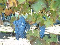
In San Javier the wine route through the wine area starts. We
visit a wine house and we buy some wine, among others a bottle of
Carmenere. Since 1860, in France, this grape was declared
extinguished because of a disease. A few years ago some
viticulturists found it back in Chile, disguised as Merlot.
The
wine route continues through some small colonial wine villages like
Yerbas Buenas and via unpaved roads we pass along many colonial wine
houses with big veranda's full of chicken and Gaucho's on horses.
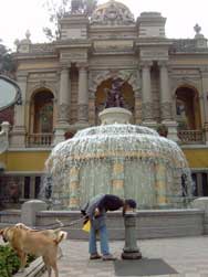 Despite our plan not to go to Santiago the Chile, we
decided to visit it at least one day. In the centre we walk to the
Plaza de las Armas and visit the centre and the cathedral, where the
recently deceased pope John Paul II is commemorated. Despite our plan not to go to Santiago the Chile, we
decided to visit it at least one day. In the centre we walk to the
Plaza de las Armas and visit the centre and the cathedral, where the
recently deceased pope John Paul II is commemorated.
In the park
Cerro Santa Lucia we picknick and have a nice panorama over the
city. In the quarter ParisLondres the houses are built in 18th
century neo-medieval style with pretty wrought balconies and gates.
At the Palacio de Moneda, where Salvador Allende was overthrown
by general Pinochet in 1973, the militaries changed guard. There
were no traces of this revolution left.
The same evening we
drove to Chile's second big city: Valparaiso.
 This is an
interesting coastal city with a pretty centre full of Art Deco
buildings. With an elevator dating from the 19th century we go up
and visit the upper part of town. We stroll along colourful wooden
19th century houses and pensions and churches and wander through
narrow cobble stone streets. This is an
interesting coastal city with a pretty centre full of Art Deco
buildings. With an elevator dating from the 19th century we go up
and visit the upper part of town. We stroll along colourful wooden
19th century houses and pensions and churches and wander through
narrow cobble stone streets.
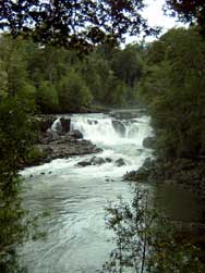
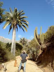
Before we drive back to the
Argentine border, we go to National park La Campana that is full of
Chilean palm trees, cacti and trees. A beautiful 5 hour walk brings
us to a waterfall, surrounded by palm trees and cacti…Very special
in this very dry area.
Coen
Click here to read about our experiences in Argentina
first before continuing with the next part of our Chile
travelogue.
Part 4: Norte Grande (15.06.05 -
06.07.05)
Written by:
Dorrit
 In Jujuy (Argentina) we do some small repairs
on the car and pick up new export documents for the dogs. On the day
we want to leave for Chile we hear that in the area we want to go to
there has been an earthquake of 7.9 on the Richter scale. Since
there might be more tremors we wait a couple of days and then head
for San Pedro de Atacama in Chile via the spectacular Paso de Jama. In Jujuy (Argentina) we do some small repairs
on the car and pick up new export documents for the dogs. On the day
we want to leave for Chile we hear that in the area we want to go to
there has been an earthquake of 7.9 on the Richter scale. Since
there might be more tremors we wait a couple of days and then head
for San Pedro de Atacama in Chile via the spectacular Paso de Jama.
Via a seemingly endless zig-zag road we climb 2000 m to the
Argentine high plateau or altiplano, an extensive flatland covered
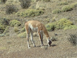
with yellow spiky grass and small herds of grazing vicunhas, a sort
of crossing between a llama and a deer. We cross a couple of salt
flats, over a dike that runs straight through the middle of these
snowy white fields.
The night at the border town at 3,700 m is
very cold; when we wake up there is a thick layer of ice on the
inside of the windscreen.
On the Chilean side of the border the
area is even more desolate than on the Argentine side; the altiplano
is surrounded by mountain and volcano peaks and punctured by several
salt lakes in the most bizarre colours, from deep dark blue to dark
red and even fluorescent green (bordered by light green ice). The
effect of algae that grow in these lakes and form the diet of the
flamingoes that live here despite the harsh climate (-20°C at night
is no exception here). Most lakes have a white crust of salt around
their borders, contrasting nicely with the brown desert landscape
surrounding it.
The Chilean customs in the oasis village of San
Pedro de Atacama are playing tennis and are not interested in
working. After letting us wait for an hour or so they give us
trouble about our dogs and take away our three potatoes, two onions
and two garlics, that you are not supposed to take into their
country. Welcome to Chile.
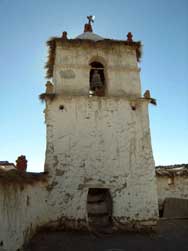
 San
Pedro de Atacama is an oase in the driest desert of the world.
Meteorologic institutes here have never recorded any rainfall! Most
of the desert looks like that too, but in San Pedro the inhabitants
have used the little river that runs through it well and made a nice
and green oasis out of their village. Adobe houses line the narrow
streets and the main square features a lovely white 17th century
adobe church. In the museum we see a lot of mummies with deformed
skulls (with bandages, the still flexible baby heads were shaped
according to the form their clan or caste distinguished itself with)
and powder boxes that the shamans used to sniff the precolombian
version of cocaine from. A habit that the Spaniards eradicated with
force to make way for - as the museum information leaflet tells us -
"nuevos valores christianos" (new christian values). San
Pedro de Atacama is an oase in the driest desert of the world.
Meteorologic institutes here have never recorded any rainfall! Most
of the desert looks like that too, but in San Pedro the inhabitants
have used the little river that runs through it well and made a nice
and green oasis out of their village. Adobe houses line the narrow
streets and the main square features a lovely white 17th century
adobe church. In the museum we see a lot of mummies with deformed
skulls (with bandages, the still flexible baby heads were shaped
according to the form their clan or caste distinguished itself with)
and powder boxes that the shamans used to sniff the precolombian
version of cocaine from. A habit that the Spaniards eradicated with
force to make way for - as the museum information leaflet tells us -
"nuevos valores christianos" (new christian values).
We
spend a few days at the beautiful Valle de la Luna (moon valley)
near San Pedro de Atacama, where we walk through a salt gorge whose
walls are made of thousands of tiny, glittering salt blocks and
where it creaks continuously. We also drive through the length of
the park, that indeed looks like a moonscape, with marvellous rock
formations in bright red, purple and rosa with white sediment
stripes, all covered in a thin layer of salt that glitters in the
sun. The valley floor seems to be an ice layer of several metres
thickness, but when I tasted it turned out to be salt as well. We
climb a giant sand dune to reach a viewpoint for the sunset over
Valle de la Luna and are looking at what seems to be a fantasy
landscape for a SF-novel: no vegetation whatsoever, everywhere
strange-shaped rocks sticking out of the sand dunes, east of the
valley an extensive salt flat and behind it the Andes that seems to
be formed of nothing but volcanoes here, all turning bright red in
the light of the setting sun.
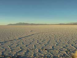
 South of San Pedro de Atacama is the Salar de Atacama, an enormous
salt lake that is now (in winter, e.g. May-Sept) dry. Here we visit
a deep and narrow canyon (Quebrada de Jerez) in the middle of the
desert. You hardly see it until you stand at the edge and look down
into it. Only then you find out that it is filled to the brim with
vegetation. With the water from the little river flowing through the
canyon, the people of the desert have turned the canyon into a real
oasis. Besides endemic plants like a white barked tree they even
grow oaks here! The walls of the canyon are made of salmon-coloured
rocks that look like dried up chunks of clay. Here we take a walk
with the dogs that play in the mud and then expect us to be happy to
take them back into the car with us.
South of San Pedro de Atacama is the Salar de Atacama, an enormous
salt lake that is now (in winter, e.g. May-Sept) dry. Here we visit
a deep and narrow canyon (Quebrada de Jerez) in the middle of the
desert. You hardly see it until you stand at the edge and look down
into it. Only then you find out that it is filled to the brim with
vegetation. With the water from the little river flowing through the
canyon, the people of the desert have turned the canyon into a real
oasis. Besides endemic plants like a white barked tree they even
grow oaks here! The walls of the canyon are made of salmon-coloured
rocks that look like dried up chunks of clay. Here we take a walk
with the dogs that play in the mud and then expect us to be happy to
take them back into the car with us.
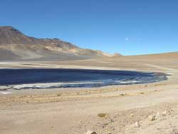
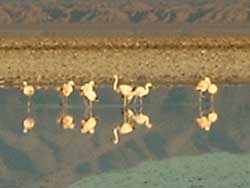
In the middle of the
dried-up Salar de Atacama there are a number of lagunas that contain
a flamingo breeding colony. At the break of dawn we are standing
ready with camera and binoculars. It is freezing cold but we are
rewarded with a large group of grazing flamingoes, that are
perfectly mirrored in the still blue water.
 Calama, west of San Pedro de Atacama, is a miners´town near the
largest open pit copper mine of the world: Chuquicamata. Although
our travel guide tells us not to drink the water here as it is
contaminated with arsenic (only one of the many negative side
effects of the mine), we fill up water here anyway, because we are
running out and the locals drink it too without dying immediately.
We spend the night in the town of Chuquicamata itself, whose
population is now being evacuated to Calama because of the air
pollution in Chuquicamata. We are allowed to stay near the police
station, next to a sign saying "Carabineros de Chile, un amigo,
siempre" (carabine holders of Chile, always your friends). Very
ironic, after so many years Pinochet.
Calama, west of San Pedro de Atacama, is a miners´town near the
largest open pit copper mine of the world: Chuquicamata. Although
our travel guide tells us not to drink the water here as it is
contaminated with arsenic (only one of the many negative side
effects of the mine), we fill up water here anyway, because we are
running out and the locals drink it too without dying immediately.
We spend the night in the town of Chuquicamata itself, whose
population is now being evacuated to Calama because of the air
pollution in Chuquicamata. We are allowed to stay near the police
station, next to a sign saying "Carabineros de Chile, un amigo,
siempre" (carabine holders of Chile, always your friends). Very
ironic, after so many years Pinochet.
The copper mine is a huge
open pit indeed: 4 kilometres long, 3 kilometres broad and 1
kilometre deep. There are plans to extend it to a lenght of 15
kilometres and a depth of 2 km. From the edge of the pit you can
look down and see how small toy cars drive to and fro with grit. Up
close the tires of these toy cars alone turn out to be thrice as
high as we are.. Chile is exporting 35% of all copper in the world
and this number is going up steadily, as the Chileans discover new
deposits of copper in the Atacama desert every day.
From
Calama we drive up to Arica in the far north of Chile. A number of
the things we wanted to see and do on the way there are impossible
to reach right now, as the roads there collapsed during last week´s
earthquake.
The first 300 km we drive through the heart of the
Atacama desert, where there is no vegetation at all. All we see are
brown hills, brown flats and more brown hills. Every now and then we
pass the ruins of deserted nitrate mine towns, whose graveyards full
of rusty brown crosses occupy more space than the ghost towns
themselves. We spend the night below a hillside with more than 350
precolombian geoglyphs on it. These are a kind of rock drawings,
featuring llamas, humans, squares and circles. The villages here are
quite damaged by the earthquake, there are fragments of buildings
lying on the street and people have put up tents next to their
houses. Despite the force of the earthquake (7.9) the damage has
been relatively little though, mainly because there was no tsunami
and because the high rise buildings in the cities were built
relatively shock proof.
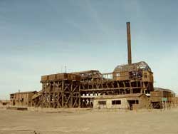 Near
the city of Iquique lies the ghost town Humberstone, a deserted
nitrate mine and accompanying miners´town from the 1880s-1950s, that
- like so many other towns in this area - did not survive the
invention of synthetic nitrate after WWII. In the 1940s over 4000
people worked and lived here and everything is still there,
crumbling and rusting. The eastern part has been badly damaged
during last week´s earthquake, but the rest can still be visited.
For more than 4 hours we ramble through the empty streets,
miners´houses and public buildings. We have a look at the swimming
pool, made from the iron of a shipwreck and rusting away slowly.
Everything looks exactly as in the high days of the 1930s and 1940s:
the wooden church, the market halls with the first "refrigerated
rooms", the tiny shops and the theatre, complete with red velvet
curtains, the school with the classic wooden school banks and the
little hospital. In one of the houses we meet a couple of elderly
men that were born and raised here and organize a reunion every
couple of months, out of a feeling of nostalgia to the good old days
in Humberstone, where there was still a community feeling. Well,
within your own class at least, because contact between the miners
and the higher employees was unheard of in those days... Near
the city of Iquique lies the ghost town Humberstone, a deserted
nitrate mine and accompanying miners´town from the 1880s-1950s, that
- like so many other towns in this area - did not survive the
invention of synthetic nitrate after WWII. In the 1940s over 4000
people worked and lived here and everything is still there,
crumbling and rusting. The eastern part has been badly damaged
during last week´s earthquake, but the rest can still be visited.
For more than 4 hours we ramble through the empty streets,
miners´houses and public buildings. We have a look at the swimming
pool, made from the iron of a shipwreck and rusting away slowly.
Everything looks exactly as in the high days of the 1930s and 1940s:
the wooden church, the market halls with the first "refrigerated
rooms", the tiny shops and the theatre, complete with red velvet
curtains, the school with the classic wooden school banks and the
little hospital. In one of the houses we meet a couple of elderly
men that were born and raised here and organize a reunion every
couple of months, out of a feeling of nostalgia to the good old days
in Humberstone, where there was still a community feeling. Well,
within your own class at least, because contact between the miners
and the higher employees was unheard of in those days... 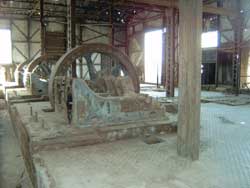 They
show us around in the owner´s villa (the Brit Humberstone, hence the
name of the town) that is normally closed to public. A couple of
kilometres further west is the mine itself, called Santa Laura.
There is also a museum here and the guard allows us to stay here for
the night. He and the owner of the little bar next to the museum
invite us for a pisco (a kind of bitter that both Peru and Chile
claim as originally theirs) in the bar. Shortly after we have
entered the bar everything suddenly starts moving, the bottles
behind the bar are jumping up and down and we were never so quick in
leaving a building in our lives. The guard is talking agitatedly
into his walkie-talkie, then tells us that it had been an earthquake
of 4 to 5 on the Richter scale, one of the many tremors that
followed the mayor earthquake last week. They
show us around in the owner´s villa (the Brit Humberstone, hence the
name of the town) that is normally closed to public. A couple of
kilometres further west is the mine itself, called Santa Laura.
There is also a museum here and the guard allows us to stay here for
the night. He and the owner of the little bar next to the museum
invite us for a pisco (a kind of bitter that both Peru and Chile
claim as originally theirs) in the bar. Shortly after we have
entered the bar everything suddenly starts moving, the bottles
behind the bar are jumping up and down and we were never so quick in
leaving a building in our lives. The guard is talking agitatedly
into his walkie-talkie, then tells us that it had been an earthquake
of 4 to 5 on the Richter scale, one of the many tremors that
followed the mayor earthquake last week.
Luckily it stays quiet
for the rest of the evening and the only thing that still moves is
the bottle of pisco. The Chileans get very drunk and keep on
offering us bottles of pisco and wine as a gift. Refusing is
impossible and at the end of the evening they drive home in their
car, not in the least bothered by the fact that they are too drunk
to even talk straight.
 After
visiting the mine (entirely made of rusting steel, the machines
still all in there) we drive another 300 km through the dry desert
and reach Arica on the last drops of diesel, because petrol stations
were non-existent in the desert. We stay at the beach north of
Arica, but although the beach is quite clean and the city of Arica
is really trying its best with some small palm trees, it is not what
I had expected from a pacific beach. After
visiting the mine (entirely made of rusting steel, the machines
still all in there) we drive another 300 km through the dry desert
and reach Arica on the last drops of diesel, because petrol stations
were non-existent in the desert. We stay at the beach north of
Arica, but although the beach is quite clean and the city of Arica
is really trying its best with some small palm trees, it is not what
I had expected from a pacific beach.
Everything is brown: the
hills behind the beach (still Atacama desert), the beach, the air
and even the sea seems brown! Every 20 m there is a sign indicating
the escape routes in case of a tsunami, apparently they are not
always so lucky as this time.
Arica itself is clean and green.
We visit the small steel church that Gustava Eiffel built here and
read our emails, finding out that my little sister Lisette is
pregnant. Hurray!
Unfortunately we caught a flu in Calama,
forcing us to stay in Arica. We try to drive up to the Lauca
national park in the Andes at the Bolivian border, but have to
return to Arica as we are too ill to go up so high.
 A
couple of days later we try again and drive back into the mountains,
from Arica at sea level (0 m) to Lauca national park (NP) at 4,600 m
in 80 km. In the cute adobe village of Putre, situated at 3,600 m
directly below a snowy peak, we spend the night between the first
scrubs and small trees since San Pedro. Near Putre, hot springs
provide some rustic pools surrounded by fringes of reeds with hot
water. Here we take a 38°C bath in the sun and recover from going up
3,600 m in one day. The next morning we start the day with a hot
bath in the sun, cup of French press coffee (thank you Suja and
Ola!) in our hands. Isn´t this the best life you can lead? A
couple of days later we try again and drive back into the mountains,
from Arica at sea level (0 m) to Lauca national park (NP) at 4,600 m
in 80 km. In the cute adobe village of Putre, situated at 3,600 m
directly below a snowy peak, we spend the night between the first
scrubs and small trees since San Pedro. Near Putre, hot springs
provide some rustic pools surrounded by fringes of reeds with hot
water. Here we take a 38°C bath in the sun and recover from going up
3,600 m in one day. The next morning we start the day with a hot
bath in the sun, cup of French press coffee (thank you Suja and
Ola!) in our hands. Isn´t this the best life you can lead?
Las
Cuevas is the first part of the Lauca NP and large herds of vicunhas
are roaming the swampy grasslands here. 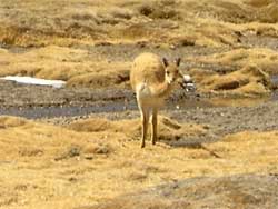 In the
1970s the NP was originally created to save these animals from
extinction and its conservation has been a great succes: within 35
years the vicunha population has risen from 1,000 to 25,000! In the
1970s the NP was originally created to save these animals from
extinction and its conservation has been a great succes: within 35
years the vicunha population has risen from 1,000 to 25,000!
Between the rocks we also see our first vizcacha´s, a kind of
big rabbit with a large squirrel-like tail that jumps from rock to
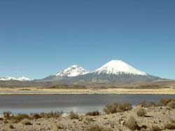
rock like a monkey. Driving further east into the park we also see
the twin peaks of the volcanoes Parinacota and Pomerape: two
perfectly symmetrical cones covered in snow behind an extensive
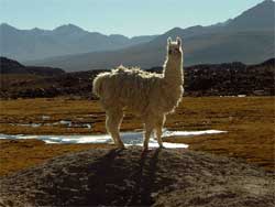
bright green swampy flat full of llamas, vicunhas and alpacas (a
smaller kind of llama that looks like a huge woolly lamb). In the
precolumbian adobe village of Parinacote, sitting at 4,500 m below
the twin peaks we spend another icy night next to a rocky area full
of vizcachas. On our last day in Chile we drive to a large border
lake full of birds (flamingoes, black ibisses, Andino-gulls etc.).
and from there it is on to the border and to Bolivia!
Dorrit
Part 5: Christmas 2005 (12.12.05 -
30.12.05)
Written by:
Dorrit
 From Ecuador we pass the mega-crowded border
of Tumbes to Peru. On the border bridge where we have to stop for
customs the crowds are so thick you can hardly see the pavement.
Everywhere you look you see ambulant traders pushing carts or
carrying weekend bags full of merchandise on their backs, street
stalls and masses of people passing by. Some miles down the road, in
the village of Tumbes, we see how a car driving 70 kmh in the centre
of town kills a dog that tried to cross the street. The driver does
not even slow down for a second. Some minutes later we see in our
rear mirrors how another car crashes into a rikshaw and its driver.
Welcome back to Peru. From Ecuador we pass the mega-crowded border
of Tumbes to Peru. On the border bridge where we have to stop for
customs the crowds are so thick you can hardly see the pavement.
Everywhere you look you see ambulant traders pushing carts or
carrying weekend bags full of merchandise on their backs, street
stalls and masses of people passing by. Some miles down the road, in
the village of Tumbes, we see how a car driving 70 kmh in the centre
of town kills a dog that tried to cross the street. The driver does
not even slow down for a second. Some minutes later we see in our
rear mirrors how another car crashes into a rikshaw and its driver.
Welcome back to Peru.
We take a few days rest in Mancora,
the lovely little beach resort we ended our last visit to Peru with.
Here we celebrate Coen´s birthday and take long walks on the beach
with the dogs. Then we drive some 3000 km along the coast of Peru to
Chile, in five long, long days. The entire route goes through the
dry, brown desert, where nothing seems to grow but a very few dusty
brown hamlets.
 The last stretch, from Nazca to the Chilean
border, follows a beautiful coastal route, that sometimes seems to
hang on the side of the steep coastal mountains, sometimes is blown
out of them. An admirable feat of engineering. Pelicans and sea
lions are swimming in the sea below us, other than that there seems
to be no life whatsoever. Such endless emptiness! The last stretch, from Nazca to the Chilean
border, follows a beautiful coastal route, that sometimes seems to
hang on the side of the steep coastal mountains, sometimes is blown
out of them. An admirable feat of engineering. Pelicans and sea
lions are swimming in the sea below us, other than that there seems
to be no life whatsoever. Such endless emptiness!
In Tacna
we struggle with the Peruvian authorities and their siesta for half
a day to get export papers for the dogs and it is dusk before we
reach the border. Both our papers and our camper van are being
examined very thoroughly and of course we have to give up our lemons
(you cannot bring any fruits, vegetables or meat into Chile). We do
not arrive in Chile before 22:00, where it is 2 hours later and
already midnight. We spend the night at the beach of Arica opposite
of an army base; here in Chile it is safe enough for wild camping
again. The beach is fully covered with dead jellyfish, there are
hundreds of thousands of them, with their dark grey bodies of some
30 cm in diameter and metres long red tentacles. In the waves of the
sea you can see there is at least as many of them left alive and
despite the heat nobody dares to swim. Brr.
 Chile looks a lot cleaner and safer than Peru, but is also a lot
more expensive and a lot less Latin-American. The only indigenous
people we see are playing pan pipe for money in the shopping mall,
just like at home! Incredible that Peru is only 15 km away.
Chile looks a lot cleaner and safer than Peru, but is also a lot
more expensive and a lot less Latin-American. The only indigenous
people we see are playing pan pipe for money in the shopping mall,
just like at home! Incredible that Peru is only 15 km away.
The
landscape however, does not change for another 5 days: the endless,
ultra-dry and empty desert goes on and on, nearly until Santiago de
Chile (i.e. another 2000 km). We pass gorgeous altiplano-like
landscapes and amazing, wild mountain ranges, but also extended sand
flats that seem to go on for ever. This is the area that Chile
conquered on Peru and Bolivia in the War of the Pacific (around
1880) and that Peru and Bolivia are still demanding back from Chile.
You would wonder why when you look around in this emptiness, but the
riches are below the surface here: copper, nitrate and many other
minerals, that together make out more than half of Chile's revenues.
No wonder this sets bad blood in Peru and especially Bolivia, which
is (still) one of the world's five poorest countries.
 On
a peninsula near Antofagasta (the second largest city of Chile and
the export harbour for the mines in the desert) we find a great spot
to camp in a small bay with our private sea lions where we celebrate
Christmas with a traditionally extensive and tasty Christmas dinner.
We are only a few kilometres south of the Tropic of Capricorn and
only a few days past the southern hemisphere's summer equinox (21
December), so during the midday hours we are without any shadow. On
a peninsula near Antofagasta (the second largest city of Chile and
the export harbour for the mines in the desert) we find a great spot
to camp in a small bay with our private sea lions where we celebrate
Christmas with a traditionally extensive and tasty Christmas dinner.
We are only a few kilometres south of the Tropic of Capricorn and
only a few days past the southern hemisphere's summer equinox (21
December), so during the midday hours we are without any shadow.
About a hundred kilometres north of Santiago it finally
starts to be a bit greener, from the first steppe grass and the
first cacti via small bushes and mini-trees to real green grass,
dark green forests and golden wheat fields. On the peaks of the
Andes there is still snow and we pass one volcano after the other.
At volcano Lonquimay we wanted to do a trek last year, but we were
too late in the season. This time we are right on time and it is
here that we say goodbye to the Pan-American Highway, which we have
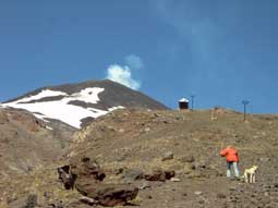
been cruising on since Quito (some 6,500 km ago).  Via cute villages with pastel coloured wooden houses that remind us
of Transylvania we drive through an Alpine spring landscape to the
national park. There we camp between the strange Araucaria trees (a
special type of pine tree, see picture) and have a great walk along
the foot of the volcano to Crater Navidad, the "Christmas Crater".
This crater was born on 25 December 1988 during an explosion on the
side of volcano Lonquimay and spat out an 8 km high cloud of dust,
ashes and rocks for an entire year, until the next Christmas. We
climb over the flank of the volcano to the crater, while the dogs
play madly in the last fields of snow. Meanwhile we have a splendid
view over the Andes to the north and south of us. We have a tea
break on the warm volcanic stone before walking back again to be
able to cross the border to Argentina that same day.
Via cute villages with pastel coloured wooden houses that remind us
of Transylvania we drive through an Alpine spring landscape to the
national park. There we camp between the strange Araucaria trees (a
special type of pine tree, see picture) and have a great walk along
the foot of the volcano to Crater Navidad, the "Christmas Crater".
This crater was born on 25 December 1988 during an explosion on the
side of volcano Lonquimay and spat out an 8 km high cloud of dust,
ashes and rocks for an entire year, until the next Christmas. We
climb over the flank of the volcano to the crater, while the dogs
play madly in the last fields of snow. Meanwhile we have a splendid
view over the Andes to the north and south of us. We have a tea
break on the warm volcanic stone before walking back again to be
able to cross the border to Argentina that same day.
Dorrit
Click here to read about our experiences in Argentina
first before continuing with the next part of our Chile
travelogue.
Part 6: Los Lagos II (11.02.06 -
14.02.06)
Written by:
Dorrit
 There are huge lines of Chileans and Argentines waiting on both
sides of the border and it is hot like an oven. We have to wait for
hours on end and to make the day the Chilean customs not only take
away our eggs, but also our bamboo walking sticks. That seemed a bit
overdone to me.
There are huge lines of Chileans and Argentines waiting on both
sides of the border and it is hot like an oven. We have to wait for
hours on end and to make the day the Chilean customs not only take
away our eggs, but also our bamboo walking sticks. That seemed a bit
overdone to me.
To compensate things Chile shows itself from
her best side during the next days: under a bright blue sky we walk
through a beautiful forested area to a high plateau named Pampa
Frutilla or "Strawberry Field".
The first day we ascend nearly
900 metres over a distance of 23 km. The walk through the forest is
just like a geography class: from broad, high trees to smaller trees
to bush to mosses and tundra grasses. The highest point of our route
leaves it at that, but when you look up along the side of the
mountain you see how the mosses make way for bare stone and above
that there is still snow. From the pass it goes down a bit to the
pampa frutilla, where we set up our tent at the border of one of the
two crystal clear mountain lakes. We are all alone here and enjoy
the silence and the possibility to cool our sore feet in the cold
water. The plain is surrounded by rough mountain peaks and rims of
dark green forest. At night the still water of the lake mirrors the
light of the full moon. What a great place!
 We wake up with a view of the rising sun, enjoy a lonely breakfast
of smuggled Argentine chorizo sausage (which the Chilean customs did
not find :o) and do some warming up by walking around the two lakes.
Our feet still hurt but the tabano's (stinging horse flies) are "out
in force" as our trekking guide had already promised us, so there is
no way of staying here any longer, no matter how beautiful this
place is.
We wake up with a view of the rising sun, enjoy a lonely breakfast
of smuggled Argentine chorizo sausage (which the Chilean customs did
not find :o) and do some warming up by walking around the two lakes.
Our feet still hurt but the tabano's (stinging horse flies) are "out
in force" as our trekking guide had already promised us, so there is
no way of staying here any longer, no matter how beautiful this
place is.
We walk back to a small field halfway, where we eat a
soup, drink a tea and hold a siesta until the horse flies go to bed.
After dinner we sit in front of our tent with a cup of tea and see
how the setting sun colours volcano Puyehue from white to yellow to
orange to red to grey.
The next day we walk the last stretch
to our camper van and drive on to the nearby thermal baths of Aguas
Calientes. There we meet Guido and Brenda from Holland, whom we had
met before in Cuzco and who join us after the hot bath. Together we
cross the border back to Argentina and find a dark grey sandy beach
at Lago Espejo (mirror lake) to chat away the night.
Dorrit
Click here to read our final travelogue.
|
| |
|
|
|
|
Our top 5: |
|
|
1. Torres
del Paine
2. NP Lauca
3. Carretera Austral
4.
Banos de Caulle
5. Valparaiso
|
|
|
|
|
|
|
|
|
Tierra del Fuego |
|
|
The main
road from San Sebastian to Cerro Sombrero is very bad.
However,
you can take the good road from San Sebastian to Porvenir and turn
into the equally good road to Bahia Azul.
|
|
|
|
|
|
|
|
|
No dogs allowed: |
|
|
1. NP Cerro
Castillo
2. NP Quelat
(Glaciar Colgante)
|
|
|
|
|
|
|
|
|
TIP |
|
|
The ferry
from Chile Chico to Puerto Ibanez costs EUR 33 for a camper and 2
persons and takes 2.5 hours.
This will save you 270 km of bad
gravel road.
|
|
|
|
|
|
|
|
|
TIP |
|
|
In Pucon,
the best thermal baths are those of Termas de los Pozones to the
north of town.
|
|
|
|
|
|
|
|
|
TIP |
|
|
The petrol
stations at the Panamericana offer brand new, spotless and warm
showers for next to nothing.
|
|
|
|
|
|
|
|
|
3rd party insurance |
|
|
You can get
the obligatory 3rd party car insurance for Chile in Arica at "Las
Americas" in shopping center Santa Maria, Av. Santa Maria.
For a 4 months-insurance we paid 7000 CL$ (EUR 12).
|
|
|
|
|
|
| |